
The Eurasian landmass spans approximately 10,700 km from east to west — from Cape Dezhnev on Russia’s Chukotka Peninsula to Cabo da Roca on the Atlantic coast of Portugal. At longitude 9°30’W, this cape is where that landmass ends.
Most people arrive expecting a dramatic finish line. What they find is a granite headland, a lighthouse that has been operating since 1772, and wind. The wind is consistent and frequently strong enough to make conversation difficult.
On a clear day, the horizon sits at approximately 46 km. Beyond it, the next landmass in a straight line west is North America. The Romans knew this point. Luís de Camões wrote about it in 1572. Portuguese navigators used it as their last reference point before weeks at sea. None of them had the option of driving 42 km from Lisbon, parking, and being back for dinner.
This article covers the geography that makes Cabo da Roca what it is, the history that built its identity, and what Camões actually wrote — not just the line that ended up on the stele.
The Geography — Where Exactly Is the Edge?
“Westernmost point of Europe” gets repeated without anyone explaining what it actually means geographically.
Cabo da Roca sits at coordinates 38°46’51″N, 9°30’2″W. That longitude — 9°30′ west of the Greenwich meridian — makes it the furthest west of any point on the continental European mainland. Further west than Finisterre in Galicia (Spain), further west than Land’s End in Cornwall (UK), further west than any point in France, Germany, or Scandinavia.
The distinction applies specifically to the continental Eurasian landmass. Portugal has territory further west — the Azores archipelago extends past 28°W — but those are Atlantic islands. Cabo da Roca holds the mainland record.
To put this in physical scale: the Eurasian landmass, the largest continuous landmass on Earth, covers approximately 54,750,000 km² and spans roughly 10,700 km at its widest east-west extent. Cabo da Roca is its Atlantic limit. From the stele on the cliff, the next landmass in a direct westward line is North America, approximately 5,500 km away.
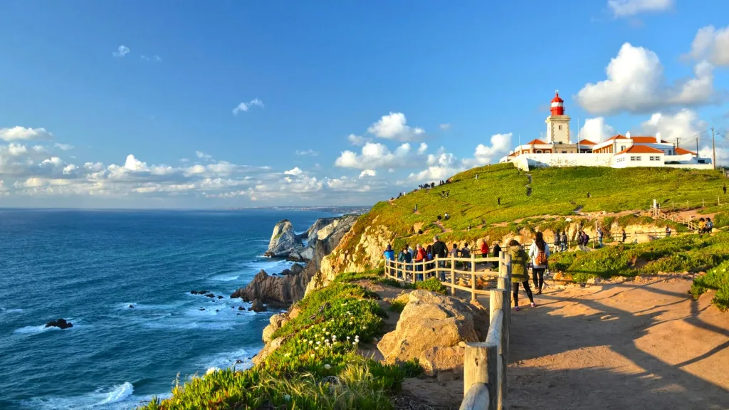
The cape is 42 km west of Lisbon, 18 km northwest of Sintra, and lies within the Sintra-Cascais Natural Park. Elevation: 140 metres at the cliff edge; 165 metres at the lighthouse focal point.
Most clients ask the same question at some point: “Is this really it?” The answer is yes. There is no hidden cape further west that we skipped.
The Geology — What the Cliffs Are Made Of
The cliff’s physical character is a direct result of geological events 80 million years ago — more interesting than “granite headland.”
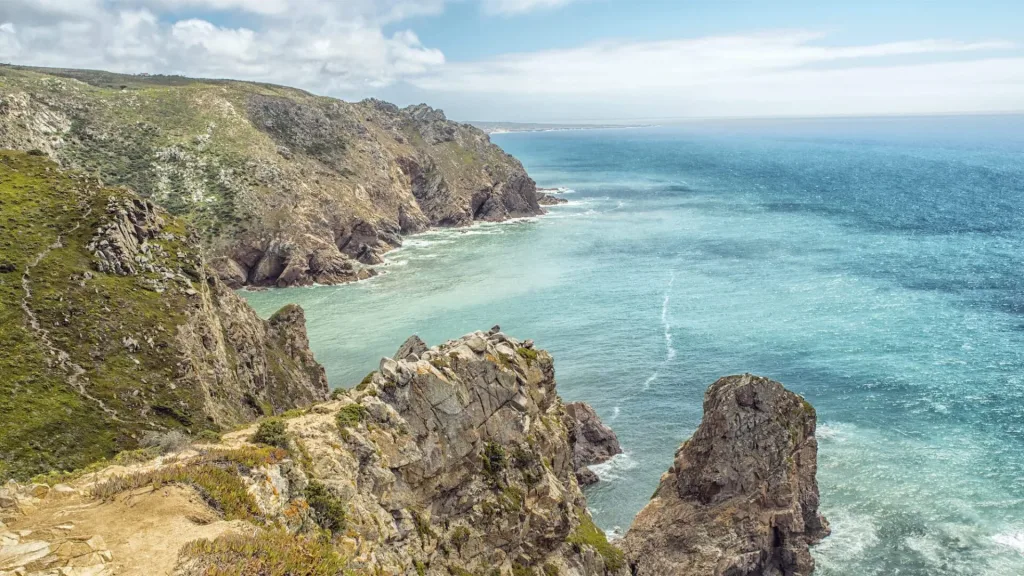
The cliffs of Cabo da Roca are composed of granite belonging to the Sintra Igneous Complex — a Late Cretaceous plutonic intrusion formed approximately 80 million years ago. At that time, magma forced its way through overlying sedimentary rock layers and cooled slowly underground, crystallising into the coarse-grained granite visible today. Subsequent erosion removed the overlying rock and exposed the granite, which the Atlantic Ocean has been working on ever since.
The Sintra Igneous Complex also includes syenite and diorite. The contact zones between the granite intrusion and the surrounding sedimentary rock are visible in the cliff faces — a geological record of the collision between magma and existing rock. The folded sedimentary layers in the cliffs record earlier tectonic events in the history of the Iberian margin.
The cliffs rise to approximately 140 metres at the cape. Winter storm waves at the base regularly exceed 10 metres in height. The cape is exposed to the full fetch of the North Atlantic — meaning waves arriving here have had thousands of kilometres of open ocean to build energy before they hit this cliff.
The granite boulders visible on the cliff faces and at the water’s edge are the result of this erosion. The process is ongoing and measurable.
The Roman Cape — Promontorium Magnum
The Romans reached this point, named it, and it marked the edge of their known western world. That has a specific historical weight worth explaining.
The Romans called Cabo da Roca *Promontorium Magnum* — “Great Promontory.” The name appears in Roman geographic texts as the outermost western reference point of their maps of the Iberian Peninsula. In Roman cartography, this cape marked the boundary between the known Atlantic world and what lay beyond.
Between 80 and 72 BC, the Roman general Quintus Sertorius used Évora — 140 km east — as his headquarters during his revolt against Rome. The cape itself served as a navigational landmark and boundary marker for Roman maritime activity along the Iberian coast. Under Roman administration, the region around Cabo da Roca was part of the province of *Lusitania*.
The cape’s designation as a geographic limit proved durable. Medieval Arab geographers referenced it. Portuguese cartographers in the 15th century used it as a fixed western reference point in their charts of the Atlantic. During the Age of Sail it acquired a second name: the Rock of Lisbon — used by northern European sailors approaching the Portuguese coast.
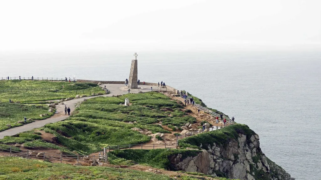
The continuity from Promontorium Magnum to the stele erected in 1979 is roughly 2,000 years of the same place being identified as the western edge of the continent.
The Lighthouse — Operating Since 1772
The lighthouse is the most visible structure at the cape, but its history connects to a specific moment in Portuguese maritime policy.
The Cabo da Roca Lighthouse began operation in 1772, making it one of the oldest continuously operating lighthouses on the European Atlantic coast. Its construction was ordered by Sebastião José de Carvalho e Melo — the Marquis of Pombal — as part of a systematic maritime safety programme following his 1758 directive to improve lighthouse coverage along the Portuguese coast.
The tower stands 22 metres tall, with a focal plane — the height of the light above sea level — of 165 metres. The structure is a red and white brick tower, classified as a third-order lighthouse, and remains an active aid to navigation operated by the Portuguese Navy’s Hydrographic Institute (*Instituto Hidrográfico*).
Visitors can approach the base of the tower but cannot enter. The lighthouse complex includes a tourism office that issues dated certificates confirming a visit to the westernmost point of continental Europe — a practice that has been running for decades and which the lighthouse complex has turned into a modest but consistent revenue stream. Whether a certificate is worth purchasing depends entirely on how much the visitor values a laminated document with their name and today’s date.
The lighthouse itself is functional. Ships passing the Portuguese coast still use it as a navigational reference, exactly as they did in 1772.

Camões and the Stele — What the Verse Actually Says
Every source quotes the one line. The full stanza is more interesting and almost never reproduced in English.
The stone stele at the Cabo da Roca viewpoint was erected in 1979 by the Municipality of Sintra. It bears a verse from *Os Lusíadas* — the Portuguese national epic written by Luís de Camões (c. 1524/5–1580) and first published in Lisbon in 1572. The line most visitors read on the stele is:
“onde a terra se acaba e o mar começa”
(“where the land ends and the sea begins”)
The full stanza — Canto III, stanza 20 — reads:
“Eis aqui, quase cume da cabeça
De Europa toda, o Reino Lusitano,
Onde a terra se acaba e o mar começa,
E onde Febo repousa no Oceano.”
In English:
“Here, almost at the very top of Europe’s head,
lies the Kingdom of Portugal,
where the land ends and the sea begins,
and where Phoebus rests in the Ocean.”
Camões is describing Portugal’s position geographically and symbolically: the kingdom at the western edge of Europe, facing the ocean into which the sun sets. Febo (Phoebus) is the sun. The cape is the threshold between known Europe and the Atlantic horizon.
A note on attribution: the verse describes the cape as a geographic reference within a broader survey of Portugal in the poem. Whether Camões visited the cape personally or wrote from geographical knowledge is not established by surviving documentation. What is established: the 1572 publication date, and the 1979 stele that fixed this particular line to this particular cliff.

The Age of Discovery Connection
This cape was the last landmark Portuguese navigators saw leaving Europe and the first they saw returning. That is worth one paragraph.
During the 15th and 16th centuries, when Portugal was operating the most sophisticated maritime exploration programme in the world, Cabo da Roca served a specific operational function: it was the last clear landmark of the European continent that departing ships could positively identify before entering open ocean, and the first recognisable reference point on the return.
Ships bound for West Africa, India via the Cape of Good Hope, or Brazil would sail from Lisbon down the Tagus and past Cabo da Roca. Those returning from months or years at sea — crews that had survived the Indian Ocean, the South Atlantic, or the coast of Brazil — would sight this headland as confirmation that they had made it back to Europe.
Vasco da Gama passed this cape in July 1497 on his first voyage to India. He returned past it in September 1499. Pedro Álvares Cabral’s fleet, which made the first European landfall in Brazil in 1500, departed past this cape. The stele records a literary verse. The operational history of the cape as a navigational landmark is less poetic and considerably more consequential.

What It Looks Like When You Arrive
Ground the experience. After history and geology, tell the reader what they will actually encounter.
The car park at Cabo da Roca is immediately adjacent to the lighthouse complex. From the car park to the cliff edge viewpoint is a two-minute walk. There are no admission fees for the viewpoint or the headland — the lighthouse exterior and the stele are freely accessible. The certificate costs extra, purchased in the tourism office.
The first thing most visitors notice is the wind. The cape is exposed to the Atlantic on three sides and has no natural windbreak. A light jacket is inadequate in autumn and winter. In summer (July–August), the cape is often clear, warm by Lisbon standards, and significantly busier — the car park fills on weekends, and the certificate queue at peak times can run 30 minutes.
The view from the cliff edge: Atlantic Ocean, horizon at approximately 46 km on a clear day, granite cliff faces dropping to the water below. Photography is best in the hour before sunset, when the light is horizontal and picks out the cliff texture. The lighthouse turns gold in this light. Most of the standard photos of this cape were taken in that window.
The GR11 coastal walking trail passes through the cape. The short circuit around the headland (2–3 km) is accessible to most visitors. The path to Praia da Ursa to the north — approximately 1.5 km, steep descent, no facilities — is one of the least-visited and most physically demanding walks near Sintra.
The entire stop, for a group that wants the viewpoint, the stele, and a certificate, runs 30–45 minutes. As a standalone destination it is brief. As part of a Sintra–Cascais day, it is the natural midpoint — geographically and atmospherically.

Visit Cabo da Roca from Lisbon


FAQ
Is Cabo da Roca really the westernmost point of Europe?
What does "westernmost point of continental Europe" mean exactly?
What is the famous quote about Cabo da Roca?
How old is the lighthouse at Cabo da Roca?
What is the elevation of Cabo da Roca?
Can you get a certificate at Cabo da Roca?
How long does a visit to Cabo da Roca take?
When is the best time to visit Cabo da Roca?
What was the Roman name for Cabo da Roca?
Is Cabo da Roca part of a natural park?

Founder & Director of Yellow Cab TT Tours. Guiding in Portugal for 20+ years.
Founded Yellow Cab TT Tours in 2013. 3,372 five-star reviews on Tripadvisor.