Cabo da Roca, Portugal: Westernmost Point of Continental Europe & Tours from Lisbon
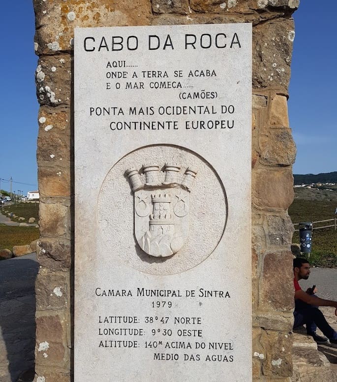
Cabo da Roca (Cape Roca) is a headland on the Atlantic coast of Portugal located at coordinates 38°47’N, 9°30’W. It is the westernmost point of mainland Portugal, continental Europe, and the Eurasian landmass – the geographic edge of a landmass that extends over 10,000 km to the east. The cape stands 165 metres above the Atlantic Ocean on granite cliffs and lies within the Sintra-Cascais Natural Park, 42 km west of Lisbon and 18 km northwest of Sintra.
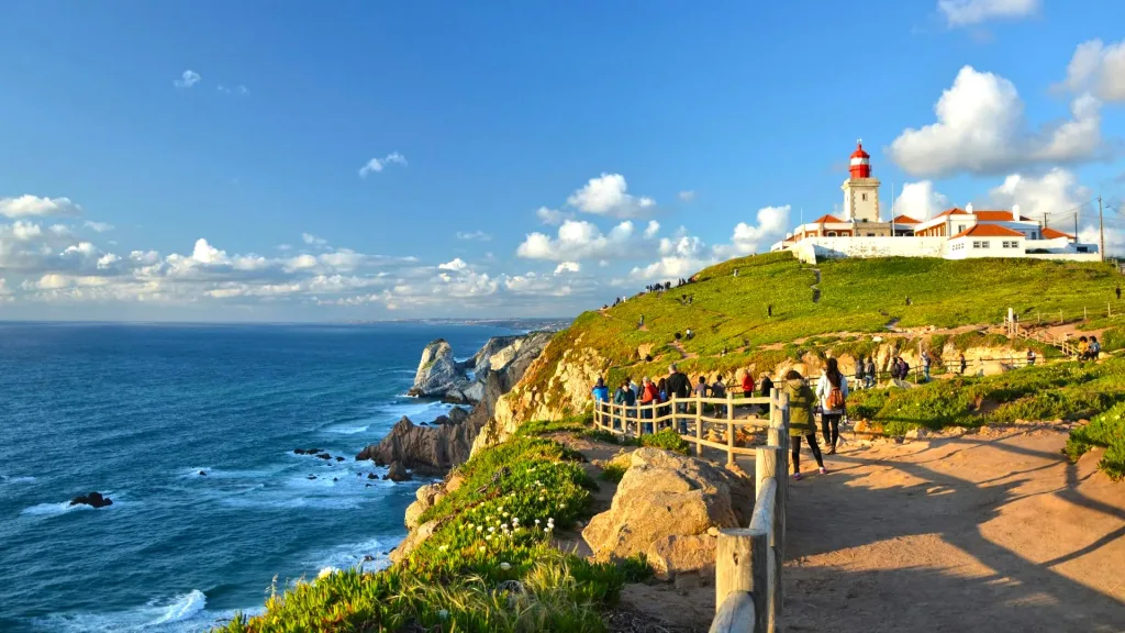
The cape is marked by a lighthouse operational since 1772 and a stone stele bearing a verse from Luís de Camões’s epic poem Os Lusíadas: “Aqui… onde a terra se acaba e o mar começa” (“Here… where the land ends and the sea begins”).
Geographic Significance - The Edge of the Eurasian Landmass
At longitude 9°30’W, Cabo da Roca is the westernmost point of continental Europe – further west than any point in mainland Spain, France, or the United Kingdom. The Eurasian landmass, which spans from Cabo da Roca in the west to Cape Dezhnev in Russia’s Chukotka Peninsula in the east, covers approximately 54,750,000 km². Cabo da Roca marks its Atlantic limit.
The cape is not the westernmost point of Portuguese territory overall – the Azores archipelago extends further west – but it holds the distinction for the continental European mainland. A certificate confirming a visitor’s presence at the westernmost point of continental Europe can be obtained at the Cabo da Roca tourism office.
The Geology of Cabo da Roca
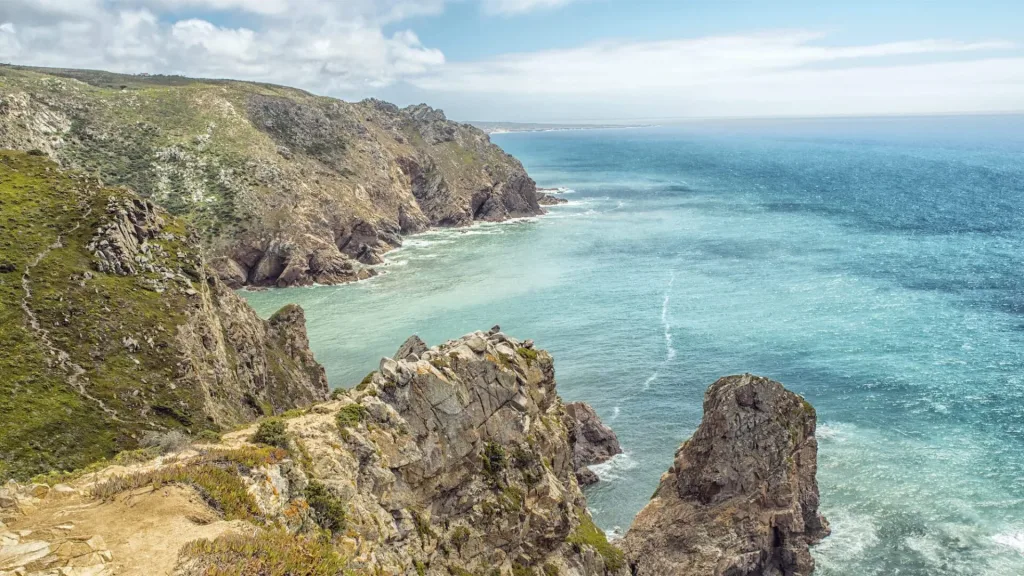
The cliffs of Cabo da Roca are composed of granite and related igneous rocks belonging to the Sintra Igneous Complex – a Late Cretaceous plutonic intrusion formed approximately 80 million years ago when molten magma forced its way through overlying sedimentary layers and cooled underground. The complex also includes syenite and diorite. The granite boulders visible on the cliff faces and at the base of the headland result from millions of years of weathering and marine erosion.
The cliffs rise steeply from sea level to approximately 140 metres, with the lighthouse platform at 165 metres. The folded and faulted sedimentary units in the surrounding rock record the tectonic history of the Iberian margin. The cape is exposed to the full fetch of the North Atlantic — storm waves in winter regularly exceed 10 metres in height here.
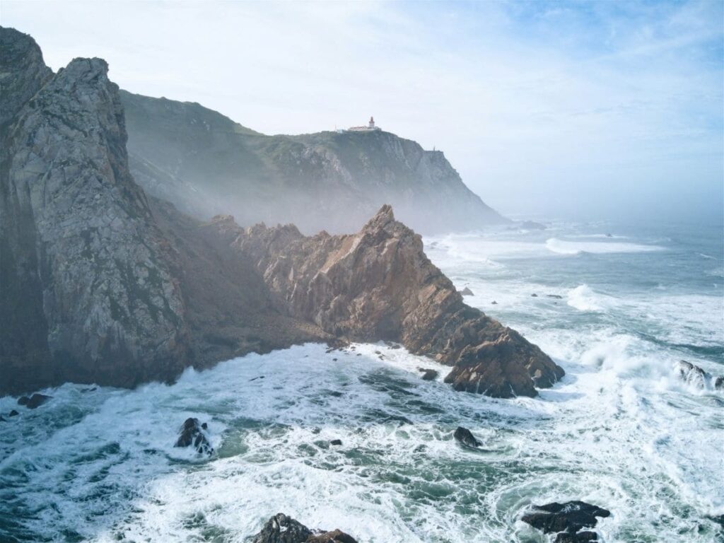
The Lighthouse (1772)
The Cabo da Roca Lighthouse was one of six lighthouses ordered to be built along the Portuguese coast by the Marquis of Pombal following his landmark maritime safety directive of 1 February 1758. Construction was completed and the lighthouse began operation in 1772. It is classified as a third-order lighthouse.
The current tower is a 22-metre red and white brick structure sitting on the cliff at 165 metres above sea level. The lighthouse is operated by the Portuguese Navy Hydrographic Institute (Instituto Hidrográfico). It remains an active aid to navigation. Visitors can approach the base of the tower but cannot enter the structure.
History - Roman Promontorium Magnum to the Age of Sail
The Romans identified the cape as Promontorium Magnum (“Great Promontory”) – the outer limit of their maps of the Iberian Peninsula. As a major geographic landmark on the Atlantic approaches to Lisbon, it served as a navigational reference point throughout the Age of Sail. During the Age of Discovery in the 15th and 16th centuries, Portuguese ships returning from Africa, Brazil and Asia would sight Cabo da Roca as the first landmark of the European mainland after weeks or months at sea. In the Age of Sail, the cape was commonly referred to as the Rock of Lisbon. In the 17th century, a fort was constructed at Cabo da Roca to help guard the western approaches to Lisbon’s harbour. The fortification formed part of a defensive network along the Sintra coast, used during the conflicts of the Peninsular War period (1807–1814).
Camões and the Literary Legacy
Luís de Camões (c. 1524/5–1580) referenced Cabo da Roca in Os Lusíadas – the Portuguese national epic, published in its first edition in Lisbon in 1572. The poem celebrates the voyages of Vasco da Gama and Portugal’s Age of Discovery. In Canto III, Camões describes the cape as “onde a terra se acaba e o mar começa” – “where the land ends and the sea begins.”
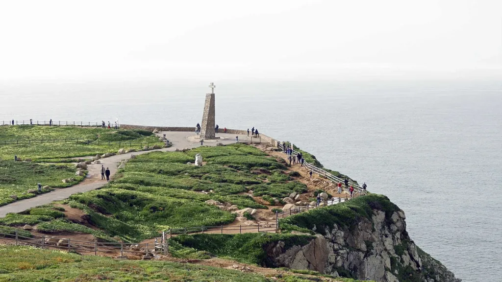
The phrase became the most widely cited literary description of the cape. A stone stele bearing this verse, erected by the Municipality of Sintra in 1979, stands at the viewpoint next to the lighthouse. The stele also records the coordinates of the cape (38°47’N, 9°30’W) and its designation as the westernmost point of continental Europe.
Note: Camões did not travel to the cape specifically to write about it – the description appears within a broader geographic survey of Portugal in the poem. Whether the verse was written based on personal observation or literary convention remains debated among scholars. What is established is the 1572 date of publication and the line’s subsequent centrality to Cabo da Roca’s cultural identity.
The Sintra-Cascais Natural Park
Cabo da Roca lies within the Sintra-Cascais Natural Park (Parque Natural de Sintra-Cascais), a protected area established in 1994 that covers the western end of the Sintra Mountain Range and the coastline between Sintra and Cascais. The park protects the granite and limestone landscape, the Atlantic coastal vegetation (including heathland, scrub and relict forest), and the cliff ecosystems where peregrine falcons nest.
The coastal trail between Cabo da Roca and Cascais (approximately 20 km) passes through the park and offers consistent views of the Atlantic. The shorter circuit around the cape headland (2–3 km) requires no special equipment and is accessible to most visitors.
What to See and Do at Cabo da Roca
The viewpoint: The cliff edge at 165 metres provides an unobstructed view of the Atlantic. On clear days, the horizon is at approximately 46 km. Winds are almost constant and frequently strong – a windproof jacket is recommended year-round.
The lighthouse: The red and white lighthouse tower (1772) is the most photographed structure at the cape. The tourism office at the lighthouse complex issues dated certificates confirming a visit to the westernmost point of continental Europe.
The stele and coordinates plaque: The stone monument erected in 1979 carries the Camões verse and the exact GPS coordinates of the cape. It serves as the primary photo reference point for visitors.
Coastal walks: The GR11 long-distance trail and shorter local paths traverse the cape headland. The trail from Praia da Ursa to the north (approximately 1.5 km by path, no facilities, steep descent) is one of the wildest coastal walks in the Lisbon region.
When to Visit Cabo da Roca
October–March | Atlantic storms, high waves (10+ m), strong winds; dramatic seascape but physically demanding.
April–June | Mild (14–20°C), fewer visitors than summer, vegetation in bloom, good light for photography.
July–August | Peak season (20–26°C); highest visitor numbers; parking can be limited; 30+ min wait for certificate.
September | Warm (18–24°C), reduced crowds, stable weather.
The cape is a 15–20 minute stop for most visitors. Photography is best in the hour after sunrise and the hour before sunset, when horizontal light picks out the cliff faces.
Getting to Cabo da Roca from Lisbon
De carro: 42 km from Lisbon via IC19 motorway to Sintra, then N247 coast road west to Cabo da Roca. Approximately 50–60 minutes. Car park at the cape. On summer weekends, arrive before 10:00 or after 17:00 to avoid parking congestion.
De autocarro: Scotturb bus 403 runs between Sintra railway station and Cascais via Cabo da Roca. Journey from Sintra: approximately 40 minutes. From Cascais: approximately 50 minutes. This is the most practical public transport option.
By train + bus: Comboios de Portugal train from Lisboa Oriente or Rossio to Sintra (40 min), then Scotturb bus 403 to Cabo da Roca.
Private Tours to Cabo da Roca from Lisbon
Cabo da Roca is most often a stop within a larger Sintra + Cascais itinerary rather than a standalone destination. The typical private tour from Lisbon includes Sintra (Pena Palace, Quinta da Regaleira), Cabo da Roca (viewpoint, 20–30 min), and Cascais (seafront, lunch).
Group Tours From Lisbon

Private Tours From Lisbon


Passeios 4x4 a partir de Lisboa

Perguntas frequentes
Is Cabo da Roca really the westernmost point of Europe?
Yes. At longitude 9°30’W, Cabo da Roca is the westernmost point of mainland Portugal, continental Europe, and the Eurasian landmass. It is not the westernmost point of Portuguese territory (the Azores extend further west) but holds the distinction for the continental European mainland.
How far is Cabo da Roca from Lisbon?
Cabo da Roca is 42 km west of Lisbon via the IC19 motorway to Sintra and the N247 coastal road. Journey time approximately 50–60 minutes by car.
What is the lighthouse at Cabo da Roca?
The Cabo da Roca Lighthouse began operation in 1772, commissioned by the Marquis of Pombal through his maritime safety directive of 1758. The 22-metre red and white brick tower sits at 165 metres above sea level and remains an active navigational aid operated by the Portuguese Navy Hydrographic Institute.
What does the stone stele at Cabo da Roca say?
The stele, erected by the Municipality of Sintra in 1979, bears a verse from Luís de Camões’s epic poem Os Lusíadas (1572): “Aqui… onde a terra se acaba e o mar começa” – “Here… where the land ends and the sea begins.” The stele also records the coordinates of the cape (38°47’N, 9°30’W).
Can you get a certificate at Cabo da Roca?
Yes. The tourism office at the Cabo da Roca lighthouse complex issues dated certificates confirming a visit to the westernmost point of continental Europe. The certificate states the visitor’s name, the date, and the coordinates. Price as of 2024: approximately €13–15 per certificate — verify current price at parquesdesintra.pt.
What is the geology of Cabo da Roca?
The cliffs are composed of granite belonging to the Sintra Igneous Complex — a Late Cretaceous plutonic intrusion formed approximately 80 million years ago. The granite was formed when magma cooled underground and was subsequently exposed by erosion. The cliffs rise to approximately 140 m above sea level; the lighthouse platform sits at 165 m.
How long does a visit to Cabo da Roca take?
Most visitors spend 20–45 minutes at the cape — time for the viewpoint, the stele, the lighthouse exterior, and the certificate (if desired). It is typically a stop within a larger Sintra + Cascais day tour rather than a standalone destination.
What is the best time of year to visit Cabo da Roca?
April to June and September offer the best balance: mild weather, fewer visitors, and good light for photography. July and August are warmest but busiest. Winter (October–March) brings Atlantic storms and dramatic wave conditions – the cape is accessible but exposed; wind speeds frequently exceed 50 km/h.
How do you reach Cabo da Roca without a car?
From Sintra, the journey by bus takes approximately 40 minutes. Sintra is reachable from Lisbon by train in approximately 40 minutes (Rossio or Oriente stations).
Is Cabo da Roca part of Sintra-Cascais Natural Park?
Yes. Cabo da Roca lies within the Sintra-Cascais Natural Park, established in 1994 to protect the western Sintra Mountain Range and Atlantic coastline between Sintra and Cascais. The park is managed by ICNF (Instituto da Conservação da Natureza e das Florestas).